Friday, September 21, 2012

Orcas Island - 09.16-18.12

In a stroke of luck I had off for two days while my father in law would be camping in the San Juan Islands. So Jennifer and I hatched the plan to join them on Orcas Island.

After Jennifer got home from work on Sunday we packed up and drove up with the intention of Mirabelle sleeping in the car. It worked and soon we she was running around on the Ferry having the time of her life, interacting with others, and enjoying the wind and views.

After the hour boat ride, a reasonable car ride got us to our campsite in Moran State Park. We had grand ambitions of heading to the summit of Mount Constitution for the sunset, but by the time we were done preparing dinner, we were all ready to call it a day. Our guests would be meeting us the following morning and we wanted to be ready.

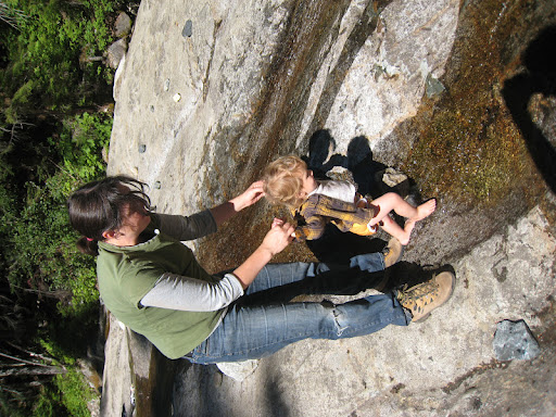
I awoke early and went for a hike near the campground while waiting for them to wake up. When I got back we had breakfast and then attempted to hike to Cascade Falls from our campground. We stopped a tenth of a mile short of the falls at a small waterfall where Mirabelle got to play with rocks and leaves before we headed back to the campground.

At the campground we found our relatives and hatched the plan to drive to the false summit of Mount Constitution and hike to the summit to give Mirabelle a nice nap, and conserve energy so she could walk down the trail. Mirabelle slept from early on to the Summit Lake and then proceeded to do her own hiking for most of the final mile on her own. Making the hike a bit longer than anticipated to reach the summit.


We stayed a while on the summit taking in the fantastic views while Mirabelle played with a new friend on the rocks.

 Mountain Lake and beyond

Mount Baker and the Twin Sisters group

Then Mirabelle got into the pack for the significantly shorter hike back to the car. We then drove into town (Eastsound) and had dinner before retiring to camp.

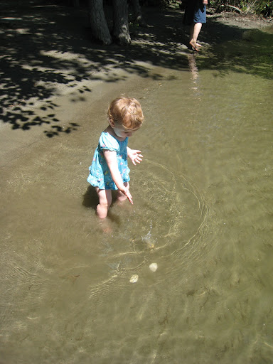
The following morning we were leaving, so we opted for a short hike to the beach at Obstruction Pass State Park. Mirabelle did the hike in by herself, and played/explored on the beach while we explored and took dips in the refreshing water.

Then we made a quick hike back to the car and an even quicker ride back to the ferry to be on time at the dock.

This was Mirabelle's first two night camping trip and she loved it! Hopefully we'll get a few more trips in the next weeks before it may get too cold for her.

Sunday, August 26, 2012

More Toddler Camping - 08.24-25.12

Another last minute decision to make the most of time off and go camping. Packing for camping with Mirabelle always seems not worth it as we struggle to wrangle her and gear to pack in the morning of a trip. This usually has Jennifer second guessing our decision to go, and also has us leaving later than I'd prefer. Not to mention forgetting some things. (more on that later)

The idea was to drive up and secure a site at Tinkham campground off I90, then take a hike up to Denny Slide while Mirabelle takes her nap. Securing a site was not a problem and we soon took the short drive over to Denny Creek Trail Head for out hike.

Mirabelle is at an age where she does not want to be cooped up in the pack for a trip and enjoys doing some of the hiking on her own. (Although she is not at an age where she can keep from getting tuckered out pretty quickly.) She wanted out of the pack early and proceeded to inspect every rock leave and hole near the trail. She didn't want to sleep in the pack or the Ergo that we brought along as well. So we all soldiered on to the slide.


It was surprising to see so many people there early on a Friday afternoon. She got good and tuckered out there, and we continued up to Keekwulee Falls while she napped in the Ergo until we got back down to the slide. She did a fair amount of the hiking back to the car and then we headed back to camp where we needed to borrow a lighter to start our stove to make dinner.

After dinner we headed to the river where Mirabelle just had to get in and wade in the South Fork.

As you can tell from the jackets, the air was not warm.

After a breakfast of fresh picked red huckleberry oatmeal, we headed to Twin Falls State Park to get in another hike. Unfortunately, all the hiking Mirabelle did the previous day left her a little too tired to accomplish that hike and we cut the hike short just after the switchbacks leading closer to the falls.

Speedy little hiker

Tuesday, August 7, 2012

Deception Pass - 08.02-.3.12

Jennifer and I both had two days off in a row. So we packed up and headed to Deception Pass for a night of car camping with Mirabelle. It has been years since we have been there. (It seems like we used to go at least once a year, but I don't remember the last time we were there.) I don't know if it exploded in popularity, or we used to visit during the off season, but we were surprised by the amount of people there. We were fortunate to get one of the last three Cranberry Lake camp sites still available on a Thursday evening.


We spent some time on West Beach before hiking up to the bridge in an effort to get Mirabelle to sleep in the ergo. I forgot just how many old growth trees there are up there. Plenty of Douglas Fir with diameters over a meter reaching fairly high into the sky. Some more interesting versions nearer the cliffs and beaches as well. We reached the bridge just as Mirabelle awoke. (Traffic noise?) We proceeding to head toward Pass Island while Mirabelle watched the water in the pass with amazement. We did a u-turn and came back following the trail we took to the bridge, now letting Mirabelle walk the safer sections.


We took a detour to North Beach and hung out a while, enjoying the many different beautiful rocks on the beach before heading back to West Beach where our car was parked.


We walked around a bit further before opting to eat dinner at one of the many picnic tables near Cranberry Lake. Mirabelle attacked a plum in the van so we gave it to her for dinner. She proceeded to make a mess of everything while we ate. Afterward, we went to the beach to watch the sunset. Mirabelle, not having had a sufficient nap went bonkers on the beach running around and falling in the sand. Then she played with the girls from a family from BC before we settled on a log to watch the sunset. It proved too long a day for Mirabelle and we retired to our campsite before the sun hit the horizon. Mirabelle didn't take too long to fall asleep and then we all slept until morning.


After a slow wake up, we went to The Bridge Cafe for breakfast. Then it was over to Rosario Beach to check out the tide pools. They unfortunately have really degraded due to human trampling. They now have ropes that you should follow to enjoy the tidal pools. We saw a few things, but the footing was not so good for Mirabelle and we returned to the beach to enjoy the fabulous rocks and skip some stones. Then we took a brief hike up Rosario Head to take in the views. We wanted to leave so we could time Mirabelle's nap with the return trip, so we had lunch and headed back done I5.


It was a fun trip, and Mirabelle seems to like camping. So hopefully we'll get out a few more times at least before this winter.

Tuesday, July 10, 2012

Southern Cascades Volcanoes - 06.25-28.12

Some stars aligned to allow Sammy and me the opportunity to drive south and get on some mountains we had never been on before. (Or in my case, never seen in person before.)

Sammy's new found love of back country skiing gave him the desire to ski a few mountains down south. Our original plan was to ski Shasta and then ski Lassen, but the NPS was supposed to close Lassen to the public for trail maintenance and we opted for a different second objective. We found that in the form of Mount McLoughlin. It would be a little less traveled, and actually on the way home.

We left Seattle on Monday after 3pm, so we made a sleep stop in Southern Oregon around midnight. We found a nice spot outside of Ashland, which was Emigrant Lake. We set up the tent in the dark and went to sleep without setting an alarm. We woke up lazily the next morning, had breakfast and headed south.

We drove to Mount Shasta (the town) and picked up our permits at the ranger station. Then we got a few supplies in town before setting off around the south side of the mountain to get to the Brewer Creek Trail Head.

Mount Shasta - Hotlum Wintun Ridge - 06.26-27.12

We arrived at the trail head around Noon. Gear needed to be sorted, so we set up a few camp chairs and slowly went about our business, eating our "lunch" while we worked. We chatted a bit with another skier from Nevada as we filled our packs and readied for our climb. Eventually we were ready and headed up the trail. There was no snow in sight and "Nevada Joe" said it would be 1000' before we got on snow. The trail was dry and the forest was thin, with no undergrowth. Numerous trees were sprouting at our feet. We hiked up the dusty trail and started crossing patches of snow before we lost the trail altogether. We had gone too far south and wandered a bit before deciding on a particular snow finger to our north and made our way toward it. I jumped on the snow as low as possible and swapped my approach shoes for ski boots and skis. Sammy went up further and made his transition at a bush, while I left my shoes under a boulder. Now the fun was starting!

We skinned up slowly and picked our way up to camp. We were hoping to go to 10000' for camp, but either the altitude or my water/food intake slowed me down. I had a headache and was not operating at full capacity. Unlike others before us, we opted to head climbers' right up a steeper section before finding a site on a rock outcrop. There were numerous bivy sites constructed and we opted for the nearest to us and the snow we were on. My altimeter read 9700'. Sammy flattened the site out while I prepped dinner. After dinner, we melted snow for water and set up the tent and lounged around before going to bed. "Nevada Joe" skied by getting some evening turns which looked pretty good.

We settled down to sleep and set an "emergency alarm" for 5am. The night was cold, but we were comfortable in the tent and slept past our alarm until the late hour of 6am. We ate breakfast and opted to boot up the firm snow leaving the tent around 7am. The snow was good for booting, and at times I was thinking I wanted crampons, but tried not to put them on until we got through a flat section at 11000'. The altitude was no longer bothering me. We rested about once per hour initially and had about three rests before we came to reside at the rock outcrop that separates the Hotlum Snow Field from the Wintun Snow Field. I was a bit ahead of Sam at this point and spent time chatting with a skier from Tahoe while waiting for him to reach my location, somewhere around 12500'.

Once Sam reached me, we had lunch and prepared for the final bit to the summit. We discussed that the next section would have us enter the final "chute" to the summit. After lunch we crossed the rocks and had another discussion.  Sam was unsure of the steeper snow slopes above and debated stashing his skis to better improve his chances of a summit. He was also concerned about how he would feel on the the steeper snow. Sam left his skis and we started up the slope. After a short period of time he was not feeling great about the steep snow and told me he was going to turn back, but that I should keep going. (In our previous discussions I was not to go to the summit if Sam turned around.) He reasoned that I was heading up with two skiers from Tahoe as well as I was close behind two skiers from Reno and that I would not be completely solo. So I continued upward. From this point on, the snow conditions and steepness of slope combined to make difficult going. There were some footprints in the initial section, but after rounding a gendarme, the wind was blowing pretty strong and footprints sometimes got blown away and a harder snow surface was left.

I wandered upward looking at my intended ski route. It did not look too difficult, but the guys before me went around to the top of the Wintun Glacier to ascend. I did not want to make my own steps, so followed theirs around the corner where the snow became icy, and steps did not exist. I wandered lonely up the windy, icy Wintun Glacier watching rime ice fall off the summit blocks. Was it from the wind or the sun, I didn't find out.

A right hand turn around the summit and I was on the plateau just below the summit and could now see west for the first time. There were a few parties hanging around and the snow went back to a fresh consistency from earlier in the week. I trudged up to the summit, happily surprised that my altimeter was reading about 600' too low.

I briefly ducked behind a rock to be out of the wind, but I felt I was in the way, so headed back down to the chute I intended to ski. There I chatted with the two guys from Reno and decided to watch them ski before making a decision. The top section was fresh skiable snow, and after about two turns, their skis started scratching on the wind crust. I made my decision to walk down. I started down with my skis on my pack, quick and easy on the skiable snow. Then I slowed going down the firm snow. I watched the two skiers slip and fall in a steeper section below me. I got a little shaken and opted to head back up the 50-100' and go back down the lower angle Wintun Glacier. The Tahoe team turned around, and now I was the only one on the upper east side of the mountain. I lost a crampon on the upper Wintun while running on the lower angle glacier. I stopped and quickly put it back on and continued downward.

Heading down the mountain is almost always physically easier, especially when altitude is a consideration. However, descending the now icier slopes on the way back down was a bit more technically demanding than when I ascended. I picked my way down and found all types of snow. At one point I down climbed face in for a few feet when I hit a section of sugar snow over crust where I was not getting any purchase. I continued face out after that and eventually saw Sam lounging at some rocks patiently awaiting my return.

Once I reached him, I continued across the rock band to my intended transition location to sit, chat, and have a bite to eat. Sammy met up with me and said he didn't like the look of the snow. Neither did I, sastrugi made up at least a few hundred feet of our initial descent. Sammy hiked lower to bypass some of it. I was done walking and braved it from my transition point. We started down. The skiing was difficult, but not survival skiing. Definitely not "no fall" skiing as I fell and slid for a way before arresting without injury. The upper part was rough though, and I did mostly long traverses with some linked turns before things softened up enough for me to link turns back to camp.

We lounged a bit at camp but then packed up for the ski out. The ski back to our shoes and down to the last bit of snow finger went well and fairly quickly. I made a few hesitant turns leaving camp on a steeper section but then skied out to my shoes while Sam retrieved his. We skied the snow to its end with our shoes in hand and then hiked a little cross country before hitting the trail and hastily following it back to the car.

We packed up and changed into driving clothes to head to Mount McLoughlin. Unfortunately, by the time we got out it was hard to find an open dinner location. We reached Fourmile Lake around 10pm and Sam and I opted to get to bed rather than fire up the stove to have a post climb dinner. I did not have high hopes for a summit the following day. I really didn't have high hopes of waking up before 10am, or wanting to do anything but go into town for some greasy breakfast. The campground was full of mosquitoes and we attempted to get to bed before being eaten.

Mount McLoughlin - Northeast Bowls - 06.28.12

We awoke around 7am and I was definitely feeling the affects of having put in 7000' of climbing in the previous two days and going to bed without dinner the night previous. I made up for it by having a whopping 900 calorie Mountain House dinner for breakfast. The mosquitoes were worse in the morning so we did some wacky dancing around trying not to get bit while we packed for the day. I was feeling better after breakfast and we made an out of the way trip to the the Lake of the Woods resort to ensure enough gasoline in the car to make it to civilization if we got out late. We also filled up all our water bladders for the day and for the ride home before heading to the trail head. We were not successful in procuring a map, but realized at the trail head that was not necessary as there was a large topo posted in the parking lot, and another about 200m up trail. Sam took a picture so we'd have it for reference on the way.

By this time of course, it was a late start. Sam wasn't worried, but I was a bit due to the fact that the later it got the worse the snow would most likely get. We hiked up dry trail and marveled at the forest being somewhat different from back in Washington, but not as dry and sparse as the forest in the Mount Shasta Wilderness. We were bothered by mosquitoes a bit and eventually we must have gained enough altitude, or the breeze kept them away and we were left to ourselves. There were plenty of carpenter ants on the trail, and at one point we saw a large toad in a tree stump, presumably feasting on said ants. (This was the wildlife highlight of our trip.)

We started hitting snow patches somewhere around 6000' and I noticed there were some footprints that looked fresh. When we stopped for a break about an hour in we had caught a party of four heading up the mountain. We passed them as they took their break and then got into more patchy snow until we veered north to gain the ridge around 7200'. Coverage to the north looked a little bare and we were concerned. But, this also looked like a good option to regain the trail if we needed to. We continued upward, now mostly on rock in second class terrain following the ridge to around 8500' where we took our final break before the summit.

The view from our rest at 8500' was much more encouraging. We saw tracks in the recent fresher snow on the north side. We scoped which lines we wished to ski and snacked on our lunches before continuing to the summit. After our break we ended up losing the trail frequently and doing some third class moves to continue upward. The south side also looked skiable in case we bailed on the north side. Although the return to trail from the south appeared much worse. Right before reaching the summit area, we got a view of the drop in to our lines. It looked steep and somewhat unforgiving. We progressed the final 100' or so to the summit area where a snow arete waited for us to get to the true summit. A short walk across and some viewing of the northwest bowls and we went back to where we dropped our packs and talked about the descent while the party of four arrived. Sam and I scouted a possible drop in from almost the summit, but I didn't like it and opted to hike a bit lower to avoid some turns that didn't make the descent any more aesthetic.

While I hiked down a bit to transition, Sam jumped the gun and got his first few turns. Then he waited for me and skied past me to a rollover. Since it was warm and late in the day we wanted to leap frog and keep our eyes on each other as we knew we should be sending down a few wet slides. Sam wanted a line skier's far left under a prominent gendarme. I was looking for a more fall line route which went down a wide chute between rock outcroppings. Sam said the rollover wasn't bad and skied the long traverse to the top of his line. I took a few turns to get a feel for it and then skied the rollover, making sure not to turn back into any slough I may have kicked off. 

While the snow had gone past corn, it was very predictable and enjoyable to ski. I moved down my line and then let Sam take some turns which set off a fairly large amount of snow. He yelled for me to wait and I watched the snow slowly chug to the bottom of the run. I then expected my slope to do the same and cautiously took turns through another rollover before deciding it wasn't going to slide and letting go of the rein. At this moment it was magical. Pretty good snow and wonderful turns down a nice fall line run. I stopped to rest my legs at some point and to let Sam get some turns in to near the leveling out point. Then I leap frogged him to a terminal moraine like mound on the other side of the flats and waited for him. He made nice figure eights out of our turns and joined me on the mound so we would have a bit of a gravity start to finish where we were going. 

Our final destination on snow was something we were calling the snow pond. From the summit area it was a round "pool" of snow at the end of a snow finger that extended east. Probably the result of numerous winter avalanches running down the course. We navigated our way through a tight constriction or two before finally reaching the snow pond and starting our transition back to booting. 

We marveled about our run and looked back on it before opting for a E/SE course through the woods to get back on a trail. This decision was made by our estimate that we were closer to the summit trail, but would have easier terrain to get to the PCT. We headed off watching our bearing and traveling on some more open terrain with boulders. The way became more wooded at some point and started to resemble the open forest we had hiked in on. Then we met up with the PCT and had a smooth hike back to the car. Except that the mosquitoes returned. Sam and I agreed that we would not linger in the parking lot so that we could avoid further mosquito harm. 

We quickly loaded the car and made our way to The Creamery in Klamath Falls where I reloaded with the Oregon Logger "burger". Then it was another 600 miles or so back to Seattle. 

Overall this trip was fantastic. Great to get on a few mountains I have not even seen before. We hit a nice weather window, although not ideal conditions for skiing. I think this could have been mitigated a bit on Shasta with an earlier start, but things worked out OK. An earlier start may have made the skiing slightly better on McLoughlin too, but that run is currently in my top favorite runs, so hard to complain about the snow condition. And of course, it was fun to hang out with Sam, a fellow father and enjoy some well needed time in the mountains, and enjoyable conversation on the long drives to and fro. 

I experimented with a helmet cam for this trip and did not take any still pictures. Photographic evidence will be forthcoming. Unfortunately I ran out of memory half way down the McLoughlin run, which is a serious bummer. But the footage I have is pretty good. 

Saturday, June 23, 2012

Toddler Camping 06.20-21.12

Or should I call this Solstice camping? In years previous I would be looking for long one day trips to attempt on the longest day of the year. I mean just under 16 hours of daylight for Seattle. A trip up to BC should clock in with 15 more minutes if you needed it, but headlamps optional for a day with that much light.

Anyway, the three of us had no obligations for two days and opted to go camping. This should have happened earlier this year, but we couldn't get our act together. We made one camping attempt back in May in the backyard, but it was so bright out, and in the tent, that Mirabelle couldn't get with the concept of sleep. We took the van this time as it provides a darker sleeping space than any of our tents.

We opted for Snoqualmie Pass on the drive out as we were hoping to get a small hike in and a longer portion for her to sleep during. Mirabelle wasn't too much into a hike under the lifts at Summit West. She wasn't into the snow too much either. So after 10-15 minutes out of the car, we had a small snack and started driving. She slept almost all the way to Leavenworth.

We were in town and it was hot. Not scorching, but hot enough that we went to Riverside Park and let Mirabelle go in the Wenatchee River. She dropped/threw rocks in and then fetched them out for a while. The water was cold but she didn't seem to mind. Eventually she went all in and we took her shirt off. After a while we hiked around the park before returning to town to wander the streets and shops. After dinner we drove up the Icicle to 8 mile to camp.


At camp we settled in and had a walk over to Icicle River where Mirabelle threw Ponderosa cones in a bit before we headed back to retire for the evening.


Even with the ridiculous amount of light, we were under some big trees and able to get Mirabelle to sleep before the sun went down. (At least that is what I think.) I was asleep shortly afterward. Unfortunately, she arose shortly after the sun around 6:30am or so and wanted out. We got ready fairly quickly and had breakfast at the picnic table in our campsite before getting on the road to a hike.

Since we didn't wish to drive far, we tried the interpretive trails at the national fish hatchery. There was some interesting things to see in the hatchery itself including a stuffed black bear and bald eagle. Outside saw raising tanks and then watched some Yakima tribe members fishing for Chinook in the Icicle before heading out on the interpretive trail. We didn't get too far before we opted to turn around as Mirabelle was already showing signs of needing a nap. That was right after we saw a small animal that may have been just a mouse, but almost looked too small and a bit yellow. But I cannot imagine what else it could have been. Perhaps the yellowish coat is more of a localized variation with all the ponderosa needles lying on the forest floor?

We hurried back to the car and Mirabelle fell asleep on the way home. She woke up in the burbs, so there was no second hike of the day.

Tuesday, June 12, 2012

Snoqualmie Mountain - 06.11.12

Went out with Steve to do a shakedown run for my upcoming trip to Shasta. I wanted to get out and get some exercise and get on skis in Spring snow to get to make sure I was up to the task of skiing a few volcanoes later this month.

The original intent was to skin up and ski the Slot Couloir. We got a lazy start in the parking lot while deciding on which ascent route to take. We eventually wound up on the Cave Ridge trail which was surprisingly not too bad this time of year. We skinned a few hundred feet before putting the skis on the packs and booting up the trail after the continuous snow disappeared. The most difficult part about heading up the trail was my skis getting caught in the alder. It was a nice morning and the ground was covered with dozens of blooming trillium. At some point the trail broke from the alder below the cliff band and we hit continuous snow again. We traversed left and crossed the creek then continued up snow on the other side. Shortly afterward, we broke onto cave ridge.

We took a short break and discussed caves and ski slopes in the area while determining which way we wanted to continue upward. We opted for the ridge and headed upward, still on boots. We enjoyed the sunny day and the somewhat cooler temps and breeze as we ascended. Eventually reaching the summit, or summit area. Steve contends the it may be the rocky outcropping to the east that is a little higher. We hung out on the summit enjoying views of the middle fork valley and attempting to identify peaks out in the distance.

We then got our skis on and skied down to the top of the slot. This ended up involving a short down climb as we stayed high and kept to the rocks. At the top of the couloir Steve surveyed it and said it looked good. Throwing some snowman heads down the couloir did not set it off. But I was not skiing well and didn't think I felt up to the making the turns for the constriction in the steep part of the gully. After some debate we opted to ski the Phantom Slide back to the car.

Steve and I leapfrogged managing wet sloughs that came down. The lower we got the less there was as the upper mountain had probably received 10-12" of snow in the past week which had not yet consolidated or bonded with the rest of the snow pack. We skiied within a close distance to the top of the waterfalls, and then booted through the woods to get back to the Snow Lake Trail. This involved two short down climbs through some cliff bands and cleaning up a rap anchor in the woods. Back to the car where it was around 70°!

This was a fun trip and demonstrated how much of a weekend warrior I have become. It was more difficult than it should have been for me. I think it would have been easier if I was in more regular practice. Forgetting sun block, was only a minor inconvenience. As well as forgetting a camera. Not being able to predict how hot/cold it would feel left me wearing pants that were too hot for most of the trip and putting on a shell for the descent to stay warm (overheat.) But these are the sort of things I needed to fine tune to think about for later this month.

Wednesday, March 21, 2012

Castle Saddle - 03.18.12

With my Mother in Law in town, I was able to escape to the mountains for some skiing with Sam. He was eager to try his new setup and get it on some deep snow.

The weather cooperated and even the avalanche forecast cooperated. We headed down to the park around 7am on Sunday. The NPS was estimating a road opening of 10am, so we had plenty of time. By the time we reached Longmire the road was open and we stopped for a services break. Then back in the car for the slow drive up to Narada Falls.

We were the fourth car in the lot as we watched two parties leave almost as soon as we arrived. Nice to have six people in front of you breaking trail when you haven't been out in a month. We geared up slowly and walked our skis over to the start of the trail hitting the snow at 10am.

The snow up the face to Steven's Canyon Road seemed stable enough to follow the skin track left by others on the face. The track in the woods appears foolishly steep and clumsy so we avoided it and headed out onto the face. In short time we were on the road above heading toward Reflection Lakes. The sun was attempting to poke out from behind the clouds, but it was generally cloudy.

We followed the skin track where it left the road through tight trees and more poor line decisions. The sun broke out briefly as well as views of Mount Rainier to just above Paradise. Then we hit a bench/bowl below the Castle Pinnacle Saddle where a group of four was digging a pit. I arrived earlier than Sammy, and watched the results of their testing. I didn't hold too much weight for it, as it was not in a spot that was representative of the slope. But it did confirm some suspicions I had about the snow pack. (Crust layer from Friday with new snow on top of it.)

We continued up, now ahead of the party of four, and chasing a party of two. We stopped at a spot near some trees to contemplate descent routes and discuss snow stability. We allowed the foursome to regain the lead. We followed them up to the saddle where visibility was lower in very flat light. Wind near the saddle made the newer snow layer on top more consolidated than down low, but we still were not seeing signs of instability.

The six other skiers headed down before us as we took our time transitioning. Since Sammy was considering this his first back country ski trip, we discussed ways to be efficient as well as our feelings on the snow pack. Some sloughs had come off Castle while the sun was out and they did not propagate. That gave us further reassurance on the stability of the snow. We leap frogged back down to the snow pit area and then skinned back up to the saddle for another run. We met a pair of skiers who were coming up for their first run of the day off the south side of the saddle.

Our second run we had decided to descend further east toward Lake Louise. We briefly stopped at one point and picked our way down what we thought would be best on terrain in an area we had never been on before, whether in summer or winter. We loosely followed some tracks laid before us and navigated our way back to the road. The snow down low was deeper and less consolidated and we enjoyed knee deep powder in places before hitting the flat road again and transitioning to skinning.

Back on the road the wind was blowing and new snow was falling fast. The skin track already had 4-5cm of new snow in it and at some point the I had to stop and put my shell and goggles on just to keep skinning into the wind. Fortunately the wind died down a bit as we got west of the lakes and by the time we got to the last hill before the lot, the sun was out and there was no wind. We transitioned one last time and took some nice turns before returning to the car.

Overall, a great outing. Snow conditions were great. It was great getting out with Sammy, who like me doesn't see as many opportunities to be in the mountains due to fatherhood.

My pics are here.

Saturday, February 25, 2012

Yodelin - 02.16.12

It has been a while. I probably should do a year end recap, or a goals for the coming year before doing a new post for a new year. But that is not how it is going to be.

In a stroke of luck I had some time off. (we were slow at work) And Dan was in between jobs. So I lobbied to get out. Unfortunately, the weather didn't really cooperate and we weren't going to riding 12" of fresh. Bummer.

The forecast was somewhat miserable with sun and above freezing temps for the day prior to us getting out. No measurable snowfall in the previous few days either. This made us fall to the old standby of Yodelin.We both figured that a northern exposure, and trees would have protected what precious snow there might be. And as always, Yodelin never seems to disappoint.


We arrived in the parking lot to a light snow falling. The road in was horrible, an icy packed luge run with a dusting of new snow on it for the minimum in friction coefficient. As we went up, the snow fell harder and the snow underfoot was deeper. We started getting positive vibes. Up near the ridge, the snow was deep, and there was no readily detectable crust. We skinned through the cut and up into the trees to our transition point.


The first run was good. A little choppy and boney in sections where people recently laid tracks. We continued to the second road and really enjoyed the less tracked lower portion. So we skinned up again. Our track from the first run had a fair amount of new snow in it, making it appear a day old. This time we went further on the ridge to get out of tracked snow and had a nicer upper portion consisting of 4-8" of loose snow. (I hesitate to call it powder. But it was not concrete.) We once again continued past the first road and had a really good run through the trees to the final road where both Dan and I fell coming through the ditch by the road. At this point and elevation we were receiving some heavy wet snow and decided to call it a day as we knew the snow wasn't getting any better. We skinned back to the lift hut and transitioned back to ride the road out.